Vail Pass Summit
Vail Pass is the only Colorado mountain pass with a bike path the entire distance on both sides, making for a wonderful ride experience. It can be reached from anywhere in Summit County and offers two distances and difficulties depending upon whether you ride just to the summit or also down the west side to Vail itself and back (see Vail Village ride).
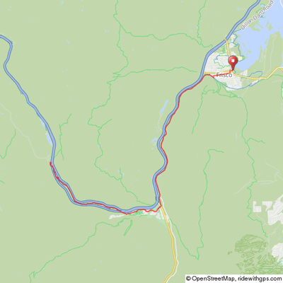
The ride to the summit is 26 miles and 1550' of climb round trip from the Frisco Marina or Frisco's west Main St. parking lot. Riding from Breckenridge adds about 18 miles and 500' of additional climb, mostly a relatively gentle grade from Frisco back to Breckenridge. The ride becomes difficult toward the top of the pass with 3 relatively steep, short switchbacks but is a moderate climb from Frisco to Copper.
Vail Pass Summit
Rest area next to I-70
Vail Pass
Climbing from Copper


From Frisco, follow the paved path from the west end of town through Tenmile Canyon for 6 miles to Copper Mountain Resort. This is a continuation of the path from Breckenridge. The trail is hidden in the woods in Ten-Mile Canyon. There is a rest area on the right side of the path about 2 miles from Frisco. Climb another 2 miles to where the path flattens out and Beaver ponds are on either side. Go another 2 miles to a parking area and a gas station cross the road into Copper Mountain Resort.
The route continues 2 miles along Copper Road to the west end of the resort where the paved path picks up on the right and continues for 4.5 miles through the valley between I-70's east and west bound lanes to the rest area at the summit.
Vail Pass Summit from Frisco Marina
Arriving back at Copper
Returning to Copper Mountain from Vail Pass

Click map for an interactive version and
downloadable GPS files.
Elevation Profile from Frisco

26 miles, 1550' of Climb
Vail Pass Summit from Breckenridge Rec Center
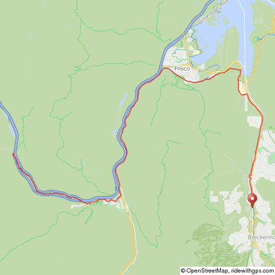
Click map for an interactive version and downloadable GPS files.
Elevation Profile from Breckeridge Rec Center

41 miles, 2,300' of Climb
